The 2008 Land Use Advisory Committee: Land Use Update
Click here to view the proposed text.
The Land Use Advisory Committee (LUAC) reviewed and drafted revisions to the Land Use Chapter. Eight citizens appointed by the Board served on LUAC. The proposals for the Transportation and Land Use/Housing chapters were drafted separately.
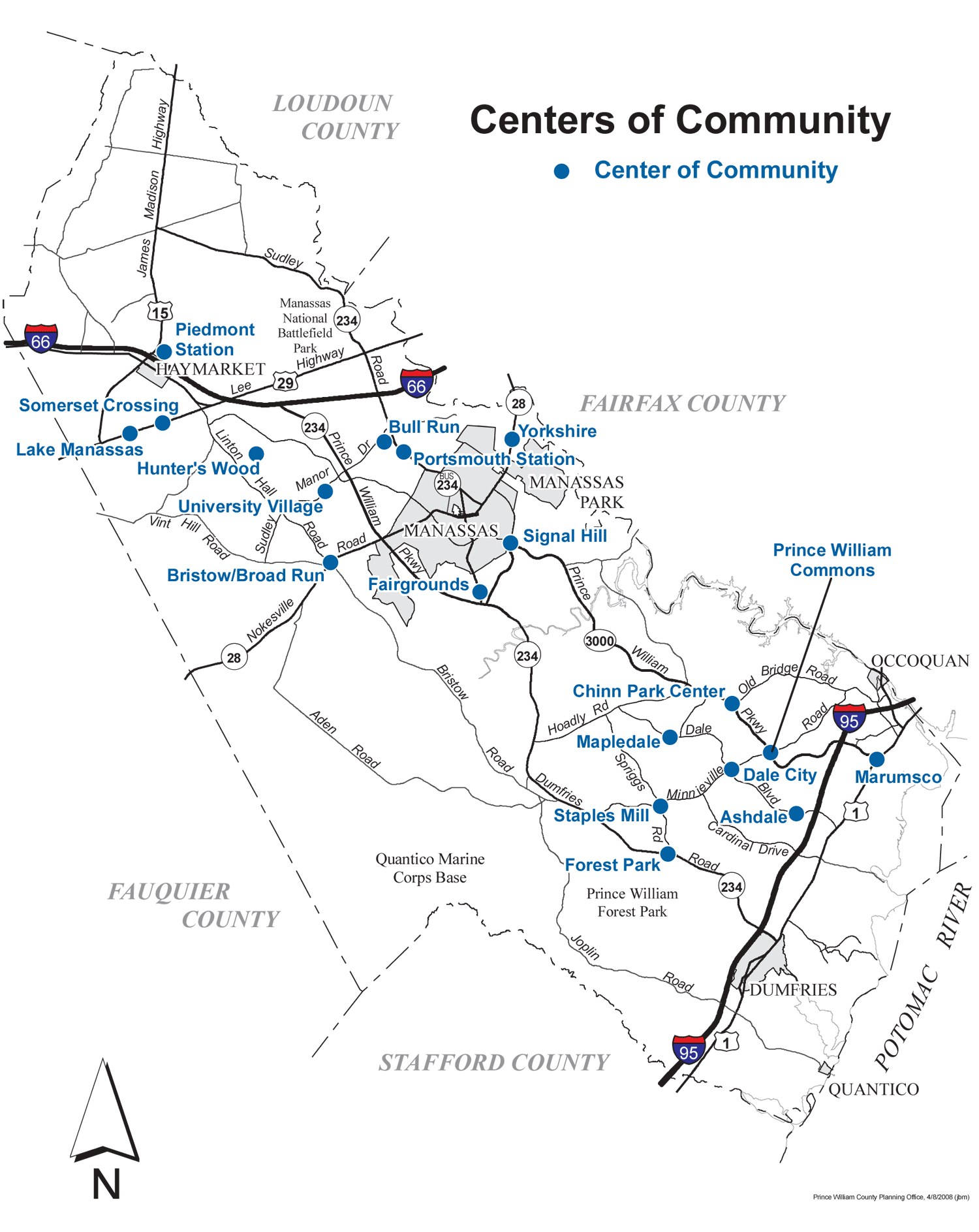
Centers of Community
Click here to view the scalable pdf map showing the locations proposed for Centers of Community and here to read relevant text.
 Sounds just like what we're looking for... but as usual, the devil's in the details. The Land Use Advisory Committee is recommending the addition of 19 "centers" that could accommodate dramatically higher population growth than is predicted by 2030. The proposed centers are scattered across the county. They lack clear boundaries and place no limits on allowed residential densities. Sounds just like what we're looking for... but as usual, the devil's in the details. The Land Use Advisory Committee is recommending the addition of 19 "centers" that could accommodate dramatically higher population growth than is predicted by 2030. The proposed centers are scattered across the county. They lack clear boundaries and place no limits on allowed residential densities.
The draft plan says the centers should "generally encompass land within ½ mile of the center." Centers with a ½ mile radius would encompass nearly 500 acres, or about three-quarters of a square mile.
If we end up with 19 dots on a map, we're opening up over 14 square miles for Center-style development. The city of Manassas (with 37,000 people) is ten square miles, while City of Alexandria (with 130,000 people) is 15 square miles.
According to the May 17, 2007, Residential Build-Out Analysis, "There is capacity for more than 49,159 dwelling units to be built." According to the 2000 Census, Prince William had 2.94 persons per household. Multiply 2.94 times 49,159 units, and as of May 2007 we had already zoned property for 144,528 more people.
Add this to the county's population as of last June 15, and we have already zoned enough parcels for a population of 525,749 people. That's more than the projected population in the year 2025 forecast: 523,668 people.
The bottom line:
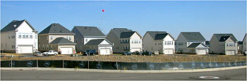
Prince William County has already zoned enough acres for residential development to accommodate the next 20 years of projected population growth - without increasing density in "centers."
Increased Densities Proposed for the Semi-Rural Residential District
 The Semi-Rural Residential (SRR) category was intended to protect Prince William's designated rural area (Rural Crescent) and the Occoquan Reservoir by providing a zone that buffered the development area's high densities. The Semi-Rural Residential (SRR) category was intended to protect Prince William's designated rural area (Rural Crescent) and the Occoquan Reservoir by providing a zone that buffered the development area's high densities.
Currently the SRR district calls for one home per every one to five acres, with an average density of one residential unit for every two and one-half acres.
The proposed changes eliminate the density restrictions and encourage development at the higher end of the density range, one home per one acre instead of one home per two and one-half acres. As stated in the draft proposal, Appendix A - The Semi-Rural Area:
-
The higher end of the density range should be allowed where properties can demonstrate suitable soils for drainfields or where public sewer can be provided.
-
Higher densities shall be achieved through negotiation at the rezoning stage.
This proposed density increase targets an environmentally sensitive area where available information strongly indicates that Prince William should instead follow the Fairfax example and move to decrease allowed densities in this area to protect our public water supply. Click here to read more...
New Legislation Links Land Use and Transportation
 VDOT's Traffic Impact Analysis Regulations, unanimously approved by the 2006 General Assembly, took effect on July 1, 2007. This goal of the regulations is to improve how land-use and transportation-planning decisions are coordinated throughout Virginia by establishing standardized procedures for analyzing transportation impacts and providing that information to citizens and policymakers. VDOT's Traffic Impact Analysis Regulations, unanimously approved by the 2006 General Assembly, took effect on July 1, 2007. This goal of the regulations is to improve how land-use and transportation-planning decisions are coordinated throughout Virginia by establishing standardized procedures for analyzing transportation impacts and providing that information to citizens and policymakers.
The regulations say that residential densities proposed for addition to the Comprehensive Plan, rezonings and Comprehensive Plan Amendments, can and should be evaluated to determine the associated impacts to the transportation system.
Responding to new legislation is one of the goals of the County's current Comprehensive Plan update. However, the proposed Land Use Chapter includes only vague criteria for the new Centers of Community, which do not have clear boundaries or limits to residential densities. This lack of clarity prevents the County from complying with the Traffic Impact Analysis Regulations, and challenges our ability to link land use and transportation planning.
Everyone needs to be talking the same language.
Vague, confusing definitions - or none at all - create loopholes, discourage citizen involvement and damage government's capacity to make development decisions predictable, fair, and cost-effective.
One policy in the proposed land use chapter is "to make development decisions predictable, fair and cost-effective" and calls for a "comprehensive list of definitions that are consistently used throughout throughout the Plan and are consistent with the Zoning Ordinance and DCSM" (PR Policy 1, AS1).
Definitions were troublesome during the recent review of the Parks & Open Space Chapter and the draft Land Use Chapter appears to be no different. In this one chapter alone, we have transit centers, mass transit centers, regional transit centers, multipurpose transit centers, transit hubs and major transit hubs. There's no definitions for any of these terms or others, such as "stable neighborhood" or "urban form."
Before adopting any plan, public officials should require a comprehensive list of definitions to avoid confusion and ensure fair play for citizens, developers and government.
Click here to for a list of vague or undefined terms used in the proposed Land Use Chapter.
Proposed Land Use Changes Deferred to a Later Date
 LUAC also proposed changes to the Long Range Land Use Map that would significantly increase planned residential densities, including: LUAC also proposed changes to the Long Range Land Use Map that would significantly increase planned residential densities, including:
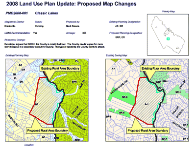
- Removing 374 acres from the Rural Crescent (click here to view proposed changes);
- Note - In the past, developers have proposed Comprehensive Plan Amendments (CPAs) for the majority of the properties proposed by LUAC for removal from the Rural Crescent. However, in response to citizen outcry, these proposals never saw the light of day. Click here to read the staff reports for the relevant 2005 proposals and here to read about the 2006 proposals (both recommend denial).
The Board of Supervisors May 20 resolution removed these proposed changes from the 2008 update and said they would be considered separately as part of the annual Comprehensive Plan Amendment (CPA) process. |