The Rural Crescent
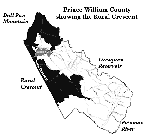
 In 1998 the Prince William County Board of Supervisors adopted a Comprehensive Plan that, for the first time, formally established an Urban Growth Boundary. The intent was to strengthen the County's capacity to control urban sprawl by defining an area that was available for higher density development and a protected rural area, which quickly became known at the Rural Crescent. In 1998 the Prince William County Board of Supervisors adopted a Comprehensive Plan that, for the first time, formally established an Urban Growth Boundary. The intent was to strengthen the County's capacity to control urban sprawl by defining an area that was available for higher density development and a protected rural area, which quickly became known at the Rural Crescent.
This was not a new concept to Prince William County decision makers. Beginning with the first county-wide Comprehensive Plan adopted by Supervisors in 1974, the County’s long-range land use plans have steered growth to areas where public services (especially public water, sewer, roads and schools) could be provided most economically.
The first plan encouraged new development near Route 1, Manassas, and Haymarket, and discouraged development in areas where growth would "overburden the capacity of existing or planned community facilities."
The plan also included two Land Use Policies restricting access to public sewer in the Rural Residential Areas, establishing the first distinction between a “development area,” where the full range of public services would be provided, and a “rural area” where public infrastructure would be limited.
The 1998 Comprehensive Plan expanded the boundary of the development area to allow new subdivisions in Gainesville and Brentsville (including Dominion Valley, Piedmont, Bristoe Village, and South Market), resulting in a rural area that resembled a crescent on the map.
Today, the county’s designated Rural Area, better known as the Rural Crescent, generally includes lands located south of the Route 234 corridor and west of Route 15. It covers approximately 80,000 acres. However, not all this land is subject to Rural Crescent densities. Some properties were already developed at greater densities than the 1 home per 10 acres allowed within the Rural Crescent. Also, the County’s criteria for Family Subdivisions continues to allow residential parcels as small as one acre within the Rural Crescent.
A concerted effort to permit high-density golf course communities in the Rural Area was rejected in 2002. The crescent-shaped boundary was retained in the 2005 and 2009 updates to the Land Use chapter, but some requests for exemptions to development limits have been approved by the Supervisors. In particular, churches have been allowed connections to public sewer for properties within the Rural Crescent. Public facilities in the Rural Area, even new schools and parks, are also permitted to connect to public sewer.
Since the Rural Crescent was adopted in 1998, new development of high-value executive homes has improved the County’s reputation as a haven of townhomes and low-end retail. Although office and other job-related development remains scarce, providing just 17% of the County’s assessed land value in 2009, higher quality retail has begun to appear in some parts of the County.
Managing land use through planning/zoning is the most cost-effective tool to minimize local property taxes. Real and personal property taxes fund new schools, fire/police stations, libraries, parks, and other public infrastructure. Prince William taxpayers also finance new roads through bonds, since the Virginia Department of Transportation has been unable to build roads fast enough to keep up with the traffic congestion created by sprawling suburbs.
Concentrating residential and commercial growth in the Development Area minimizes both initial construction and long-term maintenance costs to local taxpayers.
Protecting the Rural Crescent protects our wallets as well as our watersheds, public water supply, scenic viewsheds, and the rural character of west Prince William. However, efforts to "bust the Rural Crescent" come before the Board of County Supervisors every year.
Keep reading... |