|
Virginia Railway Express Proposed Extension to Gainesville/ Haymarket Anatomy of a Bottleneck: The U.S. Route 29/Interstate 66 Interchange at Gainesville, Virginia, by E.M. Risse, Synergy Planning |
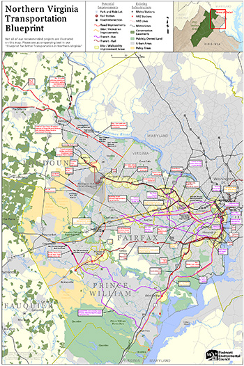
2018 Blueprint for Better Transportation in Northern Virginia It is unrealistic to pretend Northern Virginia can stop growth and simply refuse to allow construction of new houses. What we can do is shape where that growth occur. Land use and transportation plans should be coordinated so new development is encouraged in the places where it is most appropriate, and redevelopment is encouraged at selected sites. Manassas and Manassas Park are incentivizing new residential growth near the Virginia Railway Express stations. Manassas has updated its parking requirements to reflect the projection that new residents in the downtown area will use cars less often. Fairfax County is planning new “live-work-play” communities, redeveloping old commercial areas on Route 1 north of Fort Belvoir into mixed use communities. Fairfax is preparing for Bus Rapid Transit (BRT) along Route 1 south to Woodbridge, planning new transportation capacity now to minimize traffic congestion from future development. Fairfax is attracting employers to the Route 1 corridor by upgrading transit connections between the Franconia/Springfield Metro station and Fort Belvoir, so skilled workers across the region could get to jobs there without having to drive. The Blueprint identifies some specific projects in Prince William that can shape future growth to match the Mobility vision in the county’s Strategic Plan development: The Community Will Have an Accessible, Comprehensive, Multi-Modal Network of Transportation Infrastructure That Supports Local and Regional Mobility. Political talk about “fixing transportation” is cheap and repeated by candidates at each election cycle. Setting real priorities is hard, but essential. If we invest in the wrong projects, we’ll ignore lessons learned such as “we can never build enough roads fast enough to control congestion, if we keep scattering housing developments.” Let’s not perpetuate the mistakes made since sprawl began in the 1950s and fund more “dumb growth” projects designed for land speculators, such as the Bi-County Parkway and new bridges to make an Outer Beltway across the Potomac River at Route 15 and Dumfries. Specific, high-priority projects include: Route 1
Innovation
Virginia Railway Express (VRE)
Route 28/234 Bypass
Countywide
|


