 |
Activities/Events | All About PWCA | Issues | News Clips | FAQ's | Contact Info Maps | Photos | Publications | Youth Education | Links | Membership |
Where is Prince William and Why Should You Care?
Prince William County is located in Northern Virginia, about 25 miles southwest of Washington, DC. The eastern part of the county, between Interstate 95 and the Potomac River, is in the flat Coastal Plain with sandy soils. The county has about 30 miles of shoreline along the Potomac River itself.
West of Interstate 95, the landscape is in the Piedmont province with low rolling hills and typical Virginia red clay soils. Between Manassas to the base of the Bull Run Mountains is a low basin where the soils have a distinctive puplish tinge. This is a Triassic basin, formed in the time of the dinosaurs when the continents split and the Atlantic Ocean opened.
The Bull Run Mountains form the western border of Prince William County. From sea level at the Potomac River to the top of those mountains is an elevation difference of 1,280 feet.
Click here to skip to continued text.
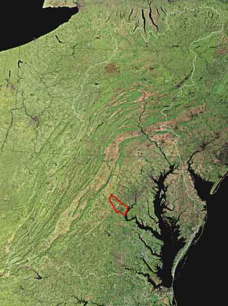 Chesapeake Bay Watershed, Showing Prince William Outlined in Red Chesapeake Bay Watershed, Showing Prince William Outlined in Red |

 |
Prince William spans from the Potomac River to historic Bull Run Mountain. Between these natural boundaries the landscape shifts from coastal plain to Piedmont conditions, with about 80 percent of the County included in the Piedmont region. As the northernmost location for southern plant species and the southernmost location for other vegetative species, Prince William is a transition area between northern and southern ecosystems. These conditions add significance to conservation efforts and highlight the regional values of Prince William's unique natural resources.
In addition to its independent ecological significance, Prince William also serves as a buffer area for the built environment. Here, the intensive land uses found in Fairfax County transition to the more rural landscape conditions of Fauquier County. Prince William development patterns have strong influences on future land uses within both Northern Virginia and the Piedmont region.
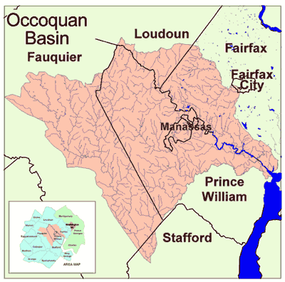
Nearly 40 percent of Prince William land drains directly into the Occoquan Reservoir, an important regional water supply. The headwaters of the Occoquan Reservoir lie in Nokesville and Gainesville, where strong development pressures are expected over the coming four years. Both areas are largely within Prince William's protected Rural Crescent. Many high quality streams still exist in west Prince William. The challenge is to prevent additional damages from poor land use choices .
All of Prince William's 220,000 acres of land drain into the Potomac River, and then to the Chesapeake Bay. Land use patterns in Prince William directly influence local water quality conditions in the Occoquan Reservoir and the Potomac River. These impacts also influence water quality conditions in the Chesapeake Bay.
Balancing clean water protection and economic growth is possible . . . and essential. The challenge in Prince William is to develop and implement protective methods before the damage is done. Contact us today to find out how you can help.