| High Density Development
One addition to the 2003 Comprehensive Plan is the Mass Transit Node (MTN) land use category, which recommends very high densities to areas around transit hubs. Theoretically, this high-rise recommendation is a smart growth' strategy modeled on Arlington County's successful efforts to relocate development around transit, which increases access to services and helps reduce traffic congestion. Relocate is the key word. The intent is to move sprawling development densities FROM outlying areas TO areas where transportation and other services are available.
The text included in the 2003 Comprehensive Plan allows the high densities around transit nodes. It does not, however, reduce densities anywhere else, such as in outlying or environmentally sensitive areas. On balance, the 2003 Comprehensive Plan includes greater residential densities countywide than in 1998.
How high are the densities for Mass Transit Nodes? Originally, Planning staff recommended a minimum density of 30 units/acre for a one-mile radius around the mass transit node. For one square mile (640 acres), the math says this means an additional 19,200 residential units . . . for just one Mass Transit Node area. For example, KSI's Springfield Station project is about 30 units/acre. This means one eight-story building with 107 residential units and seven four-story garden-style apartments with 240 units built on ten acres. This is a lot of density to add to the Comprehensive Plan without reducing planned units elsewhere.
Many developers expressed their concerns about the planned minimum density of 30 units per acre at the 2003 Comprehensive Plan Public Hearing. They requested that government consider a more flexible definition for the Mass Transit Node category. As a result, elected officials opted to defer decisions on the Mass Transit Node criteria to a later date.
The Comprehensive Plan, page 3 of the Land Use sections, states: "One of the primary intents of these urban designations is to encourage development at densities high enough to bring regional mass transit to Prince William County and better link the County to its region via mass transit."
The County's plan appears to be based on the "if you build it, they will come" concept: (1) build high-density developments, (2) which will exacerbate Prince William's current traffic congestion problems, (3) a miracle will occur and the Commonwealth will extend metro to Prince William.
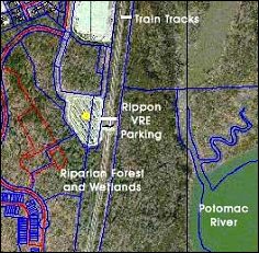 Where are Prince William's mass transit nodes? With no text or mapped descriptions to identify the sites, it's difficult to tell. Indeed, considering the limitations that restrict VRE's time schedule, some Prince William citizens have questioned whether Prince William has any mass transit nodes at all. Where are Prince William's mass transit nodes? With no text or mapped descriptions to identify the sites, it's difficult to tell. Indeed, considering the limitations that restrict VRE's time schedule, some Prince William citizens have questioned whether Prince William has any mass transit nodes at all.
Even if high-rise high-density projects could eventually attract transit options to Prince William, what happens in the meantime? The added densities would guarantee even more traffic congestion for existing residents. Plans to encourage high-density development without regional commitments for high-frequency transit in Prince William put the cart before the horse.
Mid-Density (SRR) Development
One developer proposal adopted by the Board increases densities in the Semi-Rural Residential (SRR) land use category. Currently the SRR category recommends that development proposals maintain an average density of 1 home for every 2.5 acres. The changes remove this requirement and instead pave the way for average densities of 1 home for every 1 acre anywhere “suitable soils for drainfields or access to public sewer” can be provided.
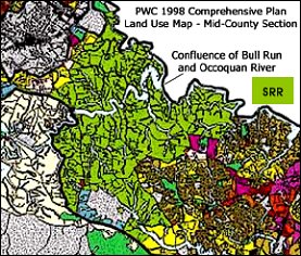 The SRR category was intended to protect Prince William's designated rural area (Rural Crescent) by providing a zone that buffered the development area's high densities. In western Prince William SRR areas abut the Rural Crescent along Broad Run and in the vicinity of Haymarket. The primary area recommended for SRR densities is mid-county. The mid-county SRR area borders the Occoquan Reservoir, the source of drinking water for eastern Prince William, and extends to the Rural Crescent. This proposed density increase targets an environmentally sensitive area where available information strongly indicates that Prince William should instead follow the Fairfax example and move to decrease allowed densities in this area to protect our public water supply. The SRR category was intended to protect Prince William's designated rural area (Rural Crescent) by providing a zone that buffered the development area's high densities. In western Prince William SRR areas abut the Rural Crescent along Broad Run and in the vicinity of Haymarket. The primary area recommended for SRR densities is mid-county. The mid-county SRR area borders the Occoquan Reservoir, the source of drinking water for eastern Prince William, and extends to the Rural Crescent. This proposed density increase targets an environmentally sensitive area where available information strongly indicates that Prince William should instead follow the Fairfax example and move to decrease allowed densities in this area to protect our public water supply.
How Much is Enough?
Prince William's current Comprehensive Plan already allocates more development than schools, roads or natural resources can accommodate. Decisions that add densities to the Comprehensive Plan add opportunities for developers and increase taxpayer investments to fund additional infrastructure.
They also limit government's capacity to manage where and when development takes place. It's harder to encourage development in preferred areas, such as brownfields like the Route 1 corridor or Sudley Road areas, when there's lots of farmland planned for houses. Developers, who are in business to make money, prefer to develop in rural areas where land is less expensive. Consequently, residents aren't sure what to expect and government officials often find themselves claiming their hands are tied.
Prince William elected officials will have a good opportunity to communicate their smart growth ideas when reviewing the Comprehensive Plan Amendment requests this coming January. Surrounding jurisdictions are using a variety of tools to manage (not eliminate) growth. Prince William has the opportunity to follow these positive examples. While there are many opinions about what “smart growth” means, it's clear that where and when development occurs is a key to protecting quality of life for Prince William residents.
Although surrounding jurisdictions are using a variety of tools to manage (not eliminate) growth, Prince William has been reluctant to follow these positive examples. Residents who are concerned with where, how . . . and when Prince William development occurs can participate in the Comprehensive Plan visioning process by contacting elected officials and sharing information with others through community meetings and letters to the editor.
Citizen comments are critical to effective Comprehensive Plan Update processes. Take advantage of every opportunity to express your support for realistic long range planning in Prince William County. You can help protect valuable natural resources and good quality of life in your community. Every voice counts. |


