Merrimac Farm Wildlife Management Area (WMA)
Merrimac Farm WMA is 302 acres of floodplain wetlands, fields, and hardwood forest that were permanently protected on January 16, 2008, and opened for public use on March 31, 2008, through a conservation partnership between Marine Corps Base Quantico, the Virginia Department of Wildlife Resources, and the Prince William Conservation Alliance.
Owned by the Virginia Department of Wildlife Resources, this Wildlife Management Area, in Nokesville, Virginia, is about 35 miles SW of Washington, D.C. (Click here for directions) and includes:
- more than one mile of riparian area along Cedar Run, a 7-acre island
- boasts one of the largest patches of Virginia Bluebells in the Northern Virginia region
- more than 100 acres of contiguous wetlands
- wetlands are protected by 200 acres of hardwood forests and upland meadows, at the headwaters of the Occoquan Reservoir and adjacent to Cedar Run

Merrimac Farm connects Quantico Marine Corps forests and wetlands with the 300-acre Cedar Run wetland mitigation bank. This connectivity enhances the conservation values of all parcels.
Conservation of this ecologically significant property secured a high-quality Northern Virginia natural area for public use and supported Virginia’s commitments to restore the Chesapeake Bay through a unique partnership.
Wetlands and vernal pools, upland fields and hardwood forests come together at Merrimac Farm, creating a diverse habitat mosaic that supports a variety of wildlife. It’s a great place to explore nature all year round. In mid-April, the floodplain wetlands along Cedar Run are blanketed with Virginia Bluebells, not to be missed.
Trail Map

Every visit is a new experience. Upland areas differ significantly from the floodplain wetlands. Planning different routes for your visit will let you explore new habitats and a broader diversity of plants and animals.
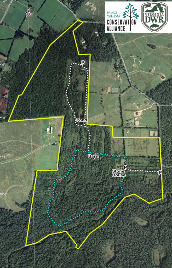
This trail map shows the main trails at Merrimac Farm. Parking is available at the Ceder Run Parking lot and the Northern Entrance. The blue dotted line shows the bluebell trail, which starts at the Stone House.
Directions
To get to the Stone House: When you are on Deepwood Lane, drive past the North Entrance to the VERY END of the road. Deepwood Lane dead ends at the Stone House. The road will transition from paved to gravel and become more narrow. Continue to follow the road to the end. Park at the Cedar Run Parking lot and walk in from there.
To go to the North Parking Lot, use the address 14712 Deepwood Land, Nokesville 20181. Park in the lot marked North Parking Lot.
Programs
Learn more by becoming a volunteer and click the button below!
- Wildlife Garden
- Bluebird Monitoring Trail
- Annual Bluebell Festival
- Christmas Bird Count – Nokesville Circle
- NABA Butterfly Survey – Manassas Circle


