| |
Lake Terrapin: What Happens When Stormwater Systems Fail
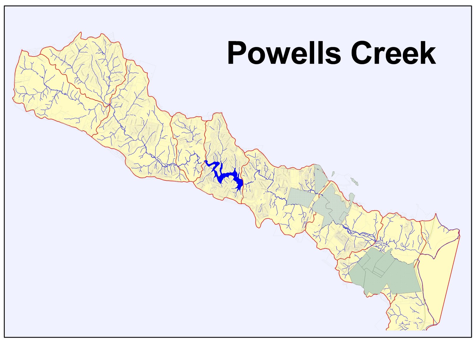
Lake Terrapin and the Powell's Creek Watershed
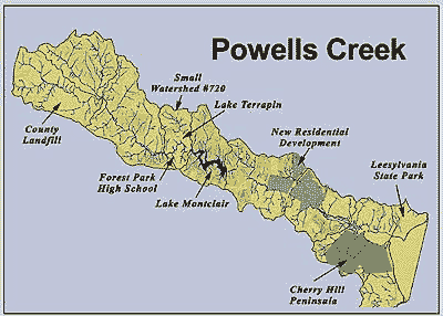
The Lake Terrapin Development, located on the east side of Spriggs Road between Minnieville Road and Route 234/Dumfries Road, is part of the Powell's Creek watershed. Powell's Creek is a direct tributary to the Potomac River.
The Powell's Creek watershed covers about 11,520 acres (18 square miles).
Powell's Creek begins near Independent Hill and flows in a southeasterly direction to the Potomac River.
From Independent Hill, Powell's Creek travels by the Prince William County landfill on Route 234/Dumfries Road. From there, Powell's Creek flows downstream to the Montclair community, where it is interrupted by Lake Montclair, and then crosses I-95 just south of Cardinal Drive. Near the Potomac River shoreline, the southern boundary for the Powell's Creek watershed generally follows Cherry Hill Road down the Cherry Hill Peninsula.
Until recently, the Powells Creek watershed was predominantly rural. Today this area faces heavy development pressure. Stream and wetland habitat conditions in the upper watershed and estuarine habitats in the lower watershed are better than in Neabsco Creek, but signs of stress from increasing development are already apparent. The challenge in Powell's Creek watershed is to develop and implement protective methods prior to and during development. 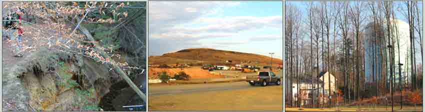
 Powell's Creek has a Natural Heritage Watershed Priority Ranking of "High." In 1992 the Virginia Institute of Marine Science's study of tidal tributary streams along the Potomac River identified the Powell's Creek estaurine area as one of the highest quality habitats of its kind in Northern Virginia. Powell's Creek has a Natural Heritage Watershed Priority Ranking of "High." In 1992 the Virginia Institute of Marine Science's study of tidal tributary streams along the Potomac River identified the Powell's Creek estaurine area as one of the highest quality habitats of its kind in Northern Virginia.
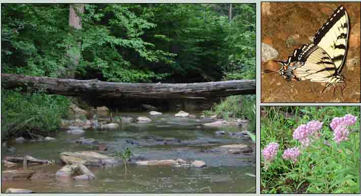
Powell's Creek is an important natural resource and provides valuable habitat for migratory birds. As many as 35 species of warblers, 25 species of ducks, geese, and swans, 24 species of raptors, 15 species of sparrows and many other avian species use the estuarine area during migration and nesting. Bald eagles nest near the confluence of Powell's Creek and the Potomac River. Blue heron and osprey are common residents in this watershed. All of the mammal species native to Virginia's Piedmont may be found in the Powell's Creek watershed area. The Powell's Creek estuary is a “nursery” for aquatic organisms and makes a significant contribution to the health of the Potomac River and the Chesapeake Bay. Initiatives such as the Virginia Coastal Birding Trail highlight the value of the Powell's Creek watershed.
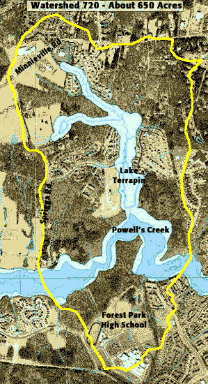
The 11,520 acres that make up the Powell's Creek watershed are divided into a set of smaller watersheds, which all drain into Powell's Creek. Lake Terrapin is part of Small Watershed #720, which covers about 700 acres. Prince William does not name the small watersheds, but the Lake Terrapin watershed would be a good name for this one.
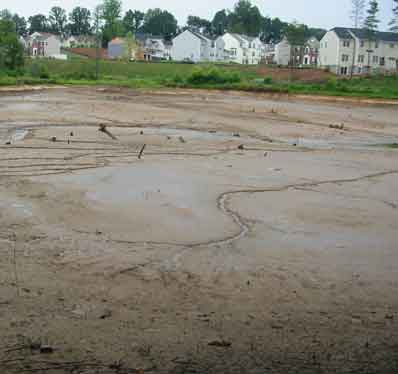
More than half the land in Watershed #720 drains into Lake Terrapin, then travels to Powell's Creek. Lake Terrapin is an approximately 6.5-acre regional stormwater pond. This pond was constructed about 30 years ago and, as ponds go, that's pretty old. Now that Lake Terrapin is empty, you can see that the basin is only a few feet deep.
Erodible soils and steep slopes are common throughout the Powell's Creek watershed. The pre-development landscape was largely forestland. Today Watershed #720 includes Forest Park High School and considerable residential development.
Lake Terrapin and the Chesapeake Bay 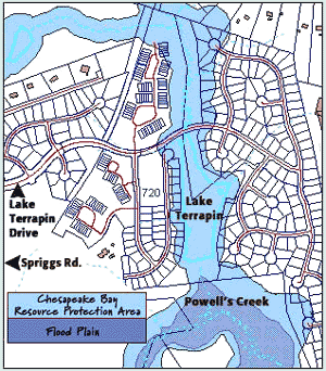
Virginia's Chesapeake Bay Regulations help protect perennial creeks (year-round water flow) from development by mandating protection for a 100-foot wide area along some creeks. This 100-foot wide protected area is called a Resource Protection Area (RPA). In the past, Prince William has not required full compliance with Virginia's Chesapeake Bay regulations. Prince William recently adopted a new, stronger set of Chesapeake Bay regulations and the County is now beginning the task of implementing these new rules consistently.
Although Prince William approved the Lake Terrapin development before the new Chesapeake Bay rules were adopted, the 100-foot wide area along creeks (RPA) was required nevertheless. Prince William's old and new Chesapeake Bay rules both require developers to complete an on-the-ground study to identify areas that qualify for protection.
Through the years, this process has been used to eliminate protection for many Prince William creeks. Citizens have often expressed frustration about this, and publicly questioned how creeks with water flow in August during a drought could avoid being classified as perennial (year-round water flow). The new rules change the criteria for classifying a creek as perennial and we are just beginning to see how this will affect development proposals.
The County approves and maps the Resource Protection Area (RPA) established by the on-the-ground study completed by the developer. Once the limits of the RPA are finalized, this land is ‘set aside.' The County subtracts the RPA acreage from the total site acreage before calculating allowable residential densities and does not allow residential lots in the Resource Protection Area (RPA).
This map of the Lake Terrapin area shows the Resource Protection Areas, as mapped by Prince William County, before the "groundtruthing" study was completed. Many lots are located either partially or completely within the Resource Protection Area (RPA) on this map. The RPA limits the County agreed to accept when approving the Lake Terrapin development are archived at Public Works, Watershed Management. A comparison of both maps would be interesting and we will post this online when it is available. (No map as of June 2005.)
Lake Terrapin is a Regional Stormwater Management Pond
 Lake Terrapin serves as a regional stormwater management pond within Small Watershed #720, which is part of the larger Powell's Creek watershed. More than half the land in this small watershed drains into Lake Terrapin before flowing on to Powell's Creek. Lake Terrapin serves as a regional stormwater management pond within Small Watershed #720, which is part of the larger Powell's Creek watershed. More than half the land in this small watershed drains into Lake Terrapin before flowing on to Powell's Creek.
Prince William County's Design and Construction Standards Manual allows regional facilities only in areas where a watershed management plan has been completed. Although regional stormwater ponds are common throughout Prince William, to the best of our knowledge the County has not completed any watershed management plans to date. Revisions to the Design and Construction Standards Manual are currently scheduled to occur by the close of 2004. Early indicators show the County poised to delete the requirement for watershed management plans from the Manual, instead of initiating studies to complete watershed management plans for critical areas. This is one example of how Prince William land use processes put the cart before the horse: build now, ask questions later.
When land is cleared to make way for development, stream hydrology changes immediately. The capacity of the pre-development landscape to absorb and store water is lost when vegetation is removed, topsoil is removed and natural drainage areas are graded. Construction activities compact the soil and replace natural landscapes with hardened (impervious) surfaces. Rainfall can no longer soak into the ground and instead runs off the surface to the nearest waterway. As the water runs off across the hardened surfaces, silt and other pollutants mix with the water and are carried to local creeks and rivers.
We know that forest and wetland functions are important for good water quality. When these natural assets are eliminated or overwhelmed, their functions must be replaced by constructed stormwater systems and filtration facilities. The ultimate goal of all stormwater management is to maintain high quality waterways. Stormwater management aims to protect drinking water sources, prevent flooding problems, preserve wildlife habitat, enhance recreational ammenities and improve the scenic appearance of communities.
Stormwater problems are predictable and preventable. New development plans are required to anticipate potential stormwater impacts and include infrastructure, such as stormwater ponds, to manage stormwater runoff effectively. Prince William land use regulations do not currently include a stormwater ordinance, which many consider a serious deficit. Instead, the County looks to the standards set by the Code of Virginia and includes some additional information in the Design and Construction Standards Manual, where minimum standards can be waived through staff-level decisions.
A University of North Carolina study on stormwater ponds underscored the importance of understanding environmental conditions within a pond's drainage area. This study found that sediment accumulations in older ponds, 30 to 45 years old, had created shallow basins. The water in these ponds was continually turbid, indicating a failure to settle suspended solids, a primary function of stormwater facilities. The study data suggested that the useful life of stormwater ponds without dredging is conservatively fifty years. Intensive development and/or inadequate stormwater infrastucture within the watershed could shorten the life span of regional facilities more quickly.
August 5, 2004 Stormwater System Breach at Lake Terrapin
Lake Terrapin has functioned as a regional stormwater management facility within Small Watershed #720 for about 30 years, well before the Lake Terrapin development was approved. Now that the pond is drained, it is easy to observe that the basin is only a few feet deep, which matches information from the University of North Carolina study on stormwater ponds.
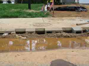
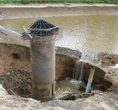
The approved development plan for Lake Terrapin allowed the use of existing stormwater infrastructure, which failed on August 5 2004. This breach at Lake Terrapin caused all the water in this approximate 6.5-acre regional stormwater pond to drain from the pond into a small, short stream and from there to Powell's Creek. As a result, stormwater infrastructure no longer protects Powell's Creek and the landscape at the Lake Terrapin development has been significantly altered.
 |
 |
The lands north of Lake Terrapin Road drain into an unnamed tributary that flows to Lake Terrapin. This small creek flows under Lake Terrapin Drive and joins the pond at the southern edge of the road. Stormwater impacts to the creek are visible on both sides of Lake Terrapin Road.
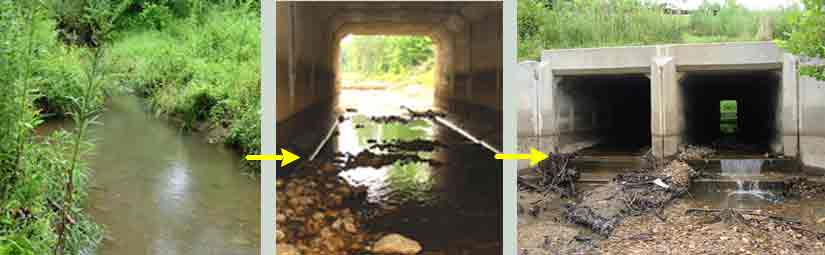
Stormwater from the land north of Lake Terrapin road drains into an unnamed tributary.
From there, it flows under Lake Terrapin Road and then into Lake Terrapin. |
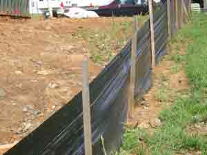
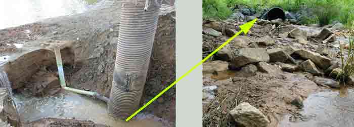
There is active construction in the immediate area around the Lake Terrapin regional stormwater pond, as shown in the pictures below. Here erosion controls, which are only about 60% effective even when properly installed and maintained, appear marginally effective at best. Erosion from this development area travels to 'Lake' Terrapin, where the failed stormwater system helps maximize impacts to Powell's Creek.
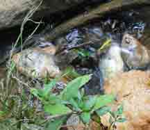
A portion of the Lake Terrapin stormwater pond continues to fill to the location of the breach and from that point drains directly into a small, short unnamed tributary that connects to Powell's Creek. The picture below show water draining from the breach into the short tributary to Powell's Creek. Why has construction in this are not been stopped until stormwater management and erosion controls are functioning effectively?
 |
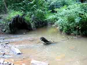
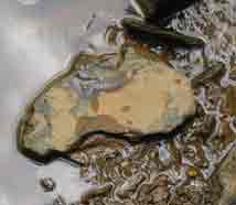
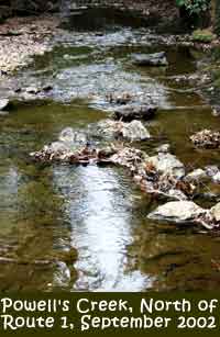
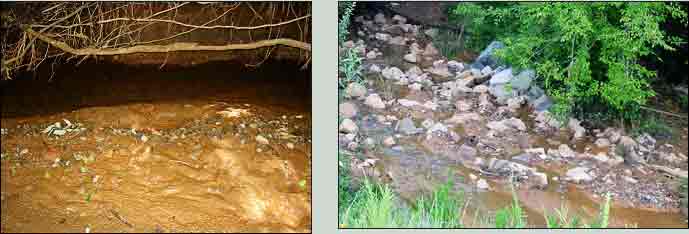
The unnamed tributary leading from Lake Terrapin to Powell's Creek was heavily impacted before the breach at Lake Terrapin. Considerable amounts of sediment line the bottom of the creek and the banks show signs of long-term erosion problems. Channelized conditions, commonly associated with drainage ditches, are apparent along some portions of the short, unnamed tributary. The breach of the Lake Terrapin stormwater system added significant impacts to this creek, already degraded by development within the small watershed. It is easy to observe the fresh layer of sediment that covers the creek bottom, as shown below, and vegetation along the stream corridor that was flattened when stormwater overflowed creek banks.
 |
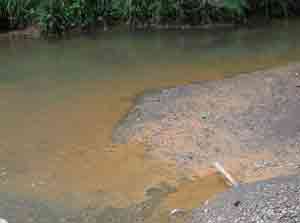
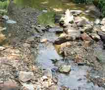
The area where this short unnamed tributary joins Powell's Creek also shows serious impacts from both previous problems and the breach at Lake Terrapin. Erosion has uprooted a large tree where the short, unnamed tributary meets Powell's Creek. A layer of fresh sediment has added to existing sediment loads, which cover aquatic habitat areas and degrade water quality conditions.
For the moment, the Powell's Creek stream corridor still appears to be in relatively good condition. Forested parcels along Powell's Creek are moving toward the development process and decisions made at those rezonings will help decide the fate of Powell's Creek.
However, degradation caused by prior and ongoing development within the small watershed is apparent. Impacts from the breach at Lake Terrapin can be observed for a considerable distance along Powell's Creek. Rocks along the bottom of the creek are covered with a new layer of sediment, vegetation along the stream corridor has been flattened by stormwater that flowed beyond the creek bank and dead fish are present some distance from the confluence with the tributary from Lake Terrapin. These impacts will continue to degrade Powell's Creek until existing problems are adequately and effectively addressed.
The breach of the Lake Terrapin stormwater system raises many questions. How many lots are either partially or completely located in the RPA? Why was the developer allowed to use a 30 year old stormwater pond to mitigate impacts from construction activities? Does the constructed stormwater system match the approved stormwater plan? Did the County grant any stormwater waivers at this site? What stormwater and other violations have been issued for this site?
Questions Remain
Why has Prince William County accepted responsibility for repairing Lake Terrapin when construction activities are still ongoing? What standards have been set for repairs to Lake Terrapin? What mitigation efforts will be completed to offset the impacts to Powell's Creek caused by the breach at Lake Terrapin?
Forested parcels near Powell's Creek are expected to enter the rezoning process in the near future, representing a new phase of the Lake Terrapin development. Will the rezoning commitments for stormwater be limited to a pro rata contribution and allow use of the Lake Terrapin regional stormwater pond, where repairs are now being funded with taxpayer dollars? Will the County allow lots to be platted in the Resource Protection Area? Will the County maintain high standards to ensure the maximum possible protection for this segment of Powell's Creek? |
|
|