| |
Development of the Cherry Hill Peninsula - Proffer Changes Do Not Address Environmental Concerns
The Cherry Hill Peninsula is widely regarded as the most environmentally sensitive land in Prince William County. The proffer changes are billed as a "kinder, gentler plan." Unfortunately, the changes would merely trade the considerable potential for environmental disaster associated with the existing plan for the long, slow death of a thousand cuts.
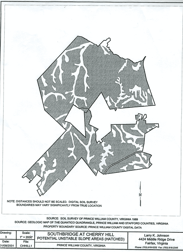
Information from a preliminary geotechnical ayalysis conducted by local watershed organizations showed:
- Topographic ground surface elevations range from about 222-feet Mean Sea Level (MSL) to 0.0-feet MSL
- Approximately 80% of the soils on this site are identified as having severe erosion potential
- The entire site is underlain by the Potomac Formation sediments (sometimes called “marine clays”) that consist of interbedded sands and clays that have a history of slope instability. Read more about "marine clays."
- On-site observations show that a massive landslide has occurred adjacent to the cut for the RF&P railroad in the northwestern section of the site
- Jusirdictional wetlands occur in several low-lying areas
- Uplands are vegetated with hardwood forest cover, except where power lines traverse the site.
- The mass grading called for in development plans would result in a situation where reestablishment of vegetation would be difficult because of soil compaction, extremely high acidity and low fertility.
- The entire site is underlain by the Potomac Formation sediments (sometimes called "marine clays") that consist of interbedded sands and clays that have a history of slope instability
- On-site observations showed that a massive landslide had occurred adjacent to the cut for the RF&P railroad in the northwestern section of the site
|
- About 75% of the Cherry Hill/Southbridge development site has 15% or greater slopes
- More than half of this site has slopes greater than 25%.
|
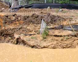
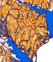
- About 80% of the soils on Cherry Hill have severe erosion potential, shown in orange. The rezonings include a proffered commitment to submit a Best Management Practices (BMP) Master Plan before the first site plan is submitted.
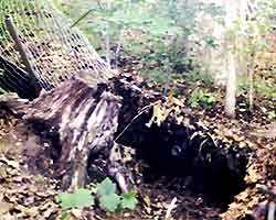
- The picture above was taken during construction of the Swann's Creek development on Cherry Hill and shows some of the serious erosion problems that occurred.
|
|
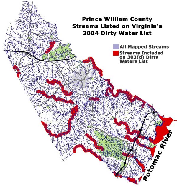
- All Prince William's tidal waterways are included on Virginia's 2004 Dirty Waters List, shown in red on the map.
- Taxpayer dollars will fund needed clean up efforts to restore these tributaries to the Potomac River and the Chesapeake Bay.
|
|