The site is bisected from northwest to southeast by Little Bull Run. This stream and a number of feeder streams feed the lake. The main lake is what is termed an in-line impoundment, meaning that an actively flowing stream was dammed to create the lake. Lakes such as this now require special exceptions because state law generally prohibits in-line impoundments (within the Resource Protection Area).
The main lake is large and centrally located. The second largest lake is the old quarry which has a brand new fence around it and will not be accessible to the public.
As you enter the property from Antioch Road, there is a mid-succession forest on your right. It still has a lot of pines, young deciduous trees and a lot of invasives in the understory. This forest was likely clear land 30 years or so ago, and appears fairly disturbed. It has restoration potential, but invasives control will be difficult.
To the left of the entrance road, there is an old field, early forest succession area which also contains quite few large white and pin oaks. This area has invasives, but it also contains a lot of good native plants. This area should be left undisturbed if possible. It has potential to mature into a good quality forest stand and good diversity of native plants.
As you continue into the property along the main road, clearings open up on both sides. On the right there are mowed areas broken up by hedgerows and old cedar tree lines. That area has a lot of turf grass in it. It is good bird habitat, but seems to have relatively low species diversity.
On the left major land disturbance is underway (silt fence, lots of newly disturbed soil with bulldozer in the middle, etc.). It appears they are building the equestrian center, although no permits posted.
Just past the cleared areas there are disturbed cedars and edge areas on the right and then the old quarry lake. You also pass a new yellow gate that seems to be the boundary between the equestrian area and the main park.
On the left is the beginning of a good quality old field system that contains non-native invasive species, but also a good diversity of native species, a small (less than one acre) old pond that is hydrologically connected with the main lake, wetlands, etc.
This is really good habitat and should be preserved. New trails have been cleared through this habitat. They were cleared of trees and rototilled to bear dirt, so these are clearly trails under construction. Luckily they do not enter wetlands, but I would highly discourage expansion of the current clearing or deeper penetration into the old field system. This area is excellent habitat for a wide variety of terrestrial, avian and wetland species.
The main gravel road splits past the yellow gate. The largest road proceeds to between the quarry lake and the main lake, crossing the main dam for the large lake. The left branch of the road leads to a several old brick dormitory buildings.
The area with the brick buildings has a lot of mowed turf, and most of the land from the brick buildings to the southeastern property boundary around the quarry lake and up to the outflowing stream from the main lake is highly disturbed and appropriate for active use.
There is a really nice wetland on the southern portion of the lake west and south of the brick buildings. There should be no trails in this area because it is the best natural wet meadow and wetland area on the property. There is recent beaver activity, tons of dragon flies and an osprey was fishing for about a half hour in this area (being observed by a great egret) while we were there.
Also on the southern edge of the lake, there is a large mowed field that contains many native meadow species include a lot of little bluestem, hairy ruellia and other species. This meadow should be preserved as a native meadow. Over time the fescue will become less dominant.
The field should not be mowed more that once per year, and the Prince William Wildflower Society would be happy to work with the Park Authority on a meadow management plan to include a burn program.
West of the lake is the old camp ground. This area is highly disturbed and suitable for active use. There are many roads, some buildings, old electrical and water hook ups, etc.
The woods on the western and northern portion of the campground should be left alone. Particularly the woods on the western portion of the camp ground are all deciduous, early late succession forest. There is evidence of disturbance, but there are a lot of native species and the forest has very good restoration potential.
The forest stand north of the campground up to Little Bull Run is more disturbed with a lot of pines. This area is mid-succession forest. One of the intriguing things here is the presence of pitch pine which, if not planted, could be a representative species that could be very interesting in terms of what community type could develop there.
From the campground around the northwest side of the lake is a mid-succession forest with a lot of disturbance and invasive species. An old road was recently reopened from the campground toward the western property boundary.
At one point, the bulldozer operator took off through the woods and cut a new road northeast parallel to the property boundary. There was flagging along this newly cleared route indicating that it was planned. However, there should not be any new clearing until further inventory can be done.
There is a large forest block north of the lake that I did not have time to explore. This forest has a very good potential from what little I saw, and no work should be done there nor any active uses planned there.
More inventory work needs to be done in this area to determine what resources are present due to the potential for a rare forest community type to be present (see below), and since this is the largest intact forest block on the property.
Around the northern part of the lake there are old clearings that are overgrown. This is a large area that had a lot of fairly recent disturbance. Toward the western end, the clearings contain natural grade.
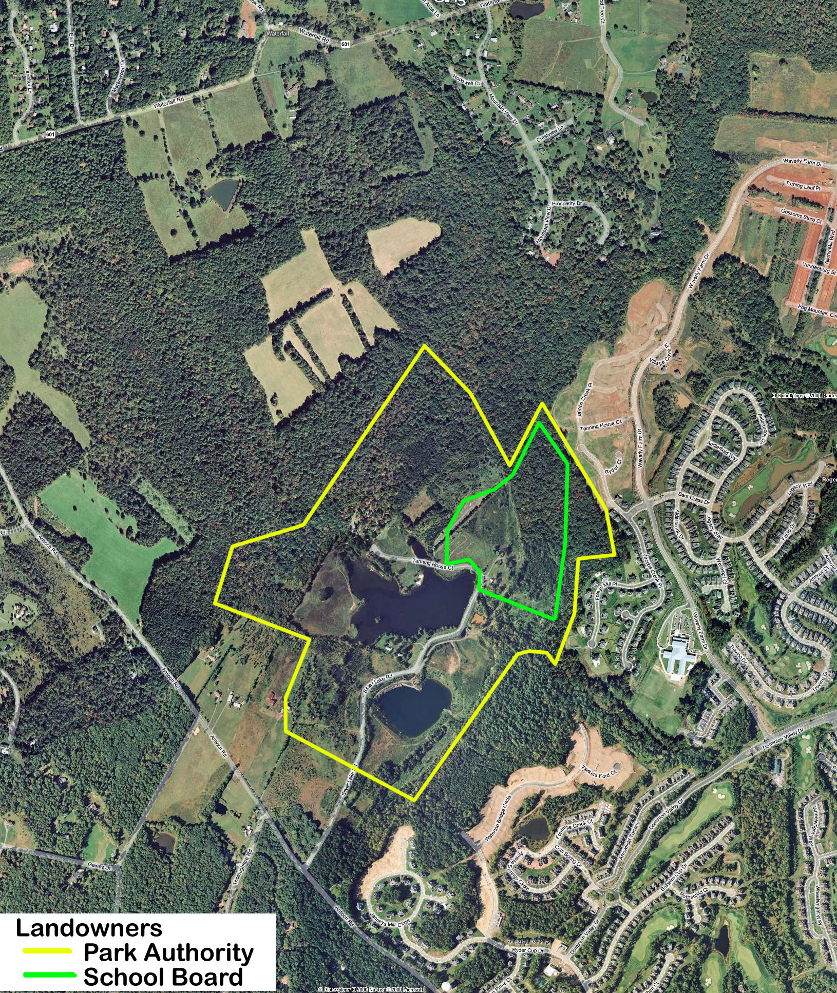
However, the clearings/old fields to the east of this toward and including the "School Site" contain dominant man-made features that consist of spoiled materials possibly from the quarrying operation. All of these open areas north of the lake are highly disturbed, contain a high percentage of cover by non-native invasive species (Japanese stilt grass, mile-a-minute vine, Johnson grass, etc.), and are suitable for active use.
The most important find on the site is the forest stand on the northeastern portion of the property (possibly extending to the northwestern portion) on what is labeled as the "School Site." This forest stand is Diabase Flatwoods, a globally rare forest community that occurs only in northern Virginia and central Maryland.
This forest type is more properly known as Basic Oak-Hickory Forest (Northern Hardpan Type). Most of this community type has been destroyed due to land clearing and alteration, but there is a nice piece of this forest type on the Silver Lake property.
I have spent a lot of time in this community type over the last several years, and here are some of the indicators that let you know what the community is: an oak-hickory forest with a high presence of ash in the overstory, almost no maple and very little tulip tree, and a grass dominant ground cover in the understory.
The first tree I encountered upon entering it is Carya ovalis (red hickory) - a species of hickory which is not common in our region but thrives in Diabase Flatwoods. There are diabase outcrops in the forest revealing the geology. Cercis canadensis (eastern redbud) is dominant in the understory. The grasses that dominate the forest floor include Muhlenbergia sobolifera (cliff muhly) and Elymus hystrix (bottlebrush grass).
This forest stand should be a preservation priority for the property. It is highly susceptible to disturbance. The presence of flagging in those woods made me very nervous. The Virginia Department of Conservation and Recreation Natural Heritage Program should be consulted for the inventory of this stand and for preservation and management recommendations.
The Fairfax County Park Authority is completing a management plan for a 235 acre tract of Diabase Flatwoods known as the Elklick Woodlands Natural Area Preserve (state designation) that could be used as a model for the management of this forest tract.
Overall, Silver Lake is an important natural area in western Prince William. It contains a diverse mosaic of habitat types that host a wide variety of native plants, insects, birds and likely a good diversity of terrestrial vertebrate species.
Bird species encountered include bluejay, northern cardinal, purple martin, eastern bluebird, Carolina chickadee, tufted titmouse, white-breasted nuthatch, red-shouldered hawk, red-tailed hawk, common raven, osprey, turkey vulture, black vulture, eastern pewee, cedar waxwing, red-bellied woodpecker, great egret, green heron, great blue heron, wood duck, Canada geese and one mute swan.
Do to the high degree of land disturbance over a large area of the site, I would highly recommend that all active uses be confined to recently disturbed areas, while high quality and restorable natural areas be preserved across the site to maintain a habitat mosaic that will support the greatest species abundance.