


| Potomac Heritage National Scenic Trail in Prince William County - Stafford County Line to Rippon Landing VRE Station Property Ownership Status for Recommended & Alternative Trail Corridors BACK TO PHNST PAGE |
| RECOMMENDED ALIGNMENT (SHORELINE CORRIDOR) | |||
| Map Index Number | Ownership Designation | Segment Length (Feet) | Description |
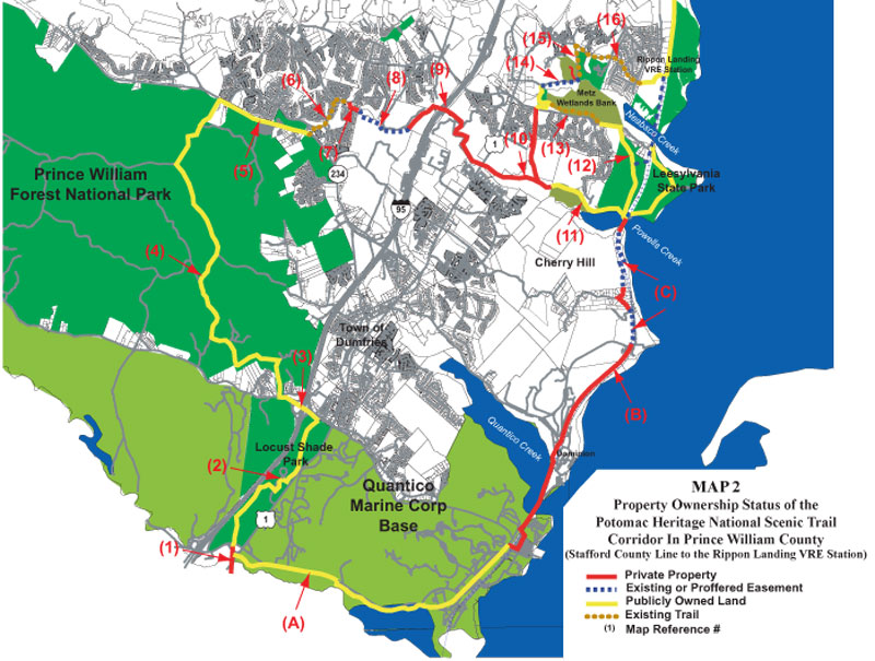
A |
Public | 28,200 |
Public lands located within Quantico Marine Corps Base. Some trail exists along Chopawamsic Creek. |
B |
Private | 15,910 |
Private lands through the Town of Quantico, along the CSX railroad right-of-way and through the Cherry Hill area. |
C |
Easement | 6,156 |
Proffered Easement. Southbridge development has proffered a trail easement with location to be determined upon submittal of site plan. |
| TOTAL | Corridor Length | 50,266 |
|
| SEGMENT SUMMARY | |||
Ownership Designation |
Segment Length (Feet) |
Miles |
Percent of Total Segment Length
|
| Private | 15,910 |
3.01 |
31.65% |
| Public | 28,200 |
5.34 |
56.10% |
| Easement | 6,156 |
1.17 |
12.25% |
| Segment Length | 50,266 |
9.52 |
100.00% |
| PRINCE WILLIAM FOREST LOOP ALTERNATIVE | |||
Map Index Number |
Ownership Designation |
Segment Length (Feet) |
Description |
1 |
Private | 2,117 |
Dominion utility right-of-way. From the Stafford County boundary north to the southern boundary of Locust Shade Park, the proposed trail corridor would be located within the Dominion utility right-of-way. |
2 |
Public | 12,512 |
Locust Shade Park. Property owned and managed by Prince William County Park Authority. Could utilize some of the existing trail network. |
3 |
Public | 3,267 |
Virginia Department of Transportation right-of-way. Route 619 right-of-way between Locust Shade Park and Prince William Forest Park to be utilized as potential trail corridor. Must be a grade separated facility. |
4 |
Public | 28,405 |
Prince William Forest Park. Property owned and managed by the National Park Service. Most of the proposed alignment does not utilize existing trails, but follows existing access roads. |
5 |
Public | 6,941 |
Virginia Department of Transportation right-of-way. The proposed trail adjacent to Route 234, between Prince William Forest and Country Club Drive (entrance to Montclair), will utilize the proposed trail facility planned during the expansion and improvement of Route 234. |
7 |
Private | 1,116 |
Montclair Golf Course and Country Club. |
8 |
Easement | 3,774 |
Easement. Corridor has been secured from Four Seasons Development along Powells Creek. |
9 |
Private | 10,985 |
Private property parcels. 1 parcel west of I-95, 2 to the east. Republic properties rezoning currently before Board of Supervisors with easement requested along Powells Creek (50 feet). |
10 |
Private | 3,658 |
Private property. Easement being sought from KSI entire distance of Powells Creek to Prince William County property as well as north along the utility right-of-way (for the Leesylvania loop trail). |
11 |
Public | 6,218 |
Public land. Parcel owned by Prince William County. A very small private parcel exists between this parcel and Leesylvania State Park. |
12 |
Public | 10,186 |
Public lands. Trail would be within the boundaries of Leesylvania State Park and in VDOT right-of-way adjacent to Neabsco Road. |
13 |
Public | 3,810 |
Utilize existing trails in the Julie Metz Wetlands bank. |
14 |
Easement | 3,117 |
Prince William County Service Authority right-of-way. |
15 |
Public | 1,879 |
Rippon Landing Park. Could possibly utilize existing trails within this public park. |
16 |
Public | 8,424 |
Local road right-of-way or local trail network. On road trail adjacent to Rippon Boulevard to VRE Station. (Portions of this are still under construction) |
| TOTAL | Corridor Length | 110,656 |
|
| SEGMENT SUMMARY | |||
Ownership Designation |
Segment Length (Feet) |
Miles |
Percent of Total Segment Length |
| Private | 17,876 | 3.39 |
16.15% |
| Public | 85,889 | 16.27 |
77.62% |
| Easement | 6,891 | 1.31 |
6.23% |
| SEGMENT LENGTH | 110,656 | 20.96 |
100.00% |
![]()
Home | Upcoming Events | About Us | Join | Resource Issues | News | Report Violations
Maps | Photos | Publications | Youth Education |FAQ's | Links | Membership
Maps | Photos | Publications | Youth Education |FAQ's | Links | Membership